Bill Lucey, Soundkeeper at Save the Sound and member of the Long Island Sound Blue Plan Advisory Council, reflects on the history of the Blue Plan effort and significance of its passage.
This post is an expansion of a Save the Sound Dispatch column written for Windcheck Magazine and published July 2021.
It finally happened at 12:21 a.m. on May 14, 2021. After 20 years of discussing the need for a plan that provides comprehensive data to spare Long Island Sound from ill-conceived development while supporting its marine dependent uses and ecology, the Long Island Sound Blue Plan unanimously passed both chambers of the Connecticut General Assembly.
But before that could happen, there were regional fights like the Iroquois Pipeline, Cross-Sound Cable, Islander East, and Shell Oil’s Broadwater. Those battles brought together the region’s scientists, advocates, policy makers, business representatives, municipal leaders, seafood harvesters, marine-trades representatives, and other stakeholders in a bi-state initiative to stop the cycle of poorly planned, destructive proposals. That effort led to the 2015 statutory Blue Plan Advisory Council, which was guided by the vision of a “Long Island Sound where new and existing traditional uses are mutually compatible with the habitats and natural features needed for marine life to thrive, assuring the wellbeing and prosperity of current and future generations.” (Blue Plan Vision and Goals, June 2017)
In partnership with the Connecticut Department of Energy and Environmental Protection (DEEP), the council cataloged the Sound’s marine resources and uses like oystering and shipping then developed a plan to safeguard them by establishing siting priorities, standards, and management practices. Three core pillars steered the process:
- Science-based planning and practices that consider both the environment and human uses will help us understand and protect Long Island Sound ecosystems and the services they provide;
- An inclusive, transparent, stakeholder-endorsed and science-based Blue Plan decision-making process that is consistent with other plans and legal requirements will lead to decisions supporting the long-term vision for compatibility of human uses and thriving marine life; and
- Science-based planning and practices that consider both human uses and the environment will sustain traditional and facilitate compatible new water dependent uses to enhance quality of life and compatible economic development including maintaining the ecosystem services they depend upon.

The Blue Plan will now become part of the Connecticut Coastal Management Program and will officially guide DEEP and the CT Department of Agriculture’s Division of Aquaculture as they review applications for uses of the Sound.
Among other highlights, the plan:
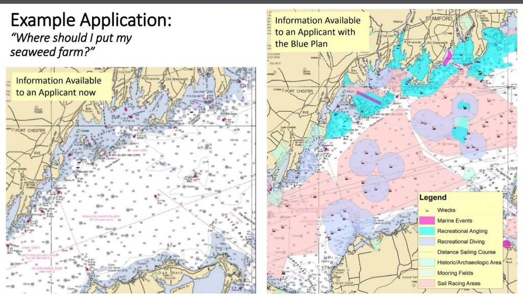
- Identified important ecological areas which is beneficial for tracking recovery or decline of habitat and species and allows both regulators and potential developers a clear picture of impacts that might arise from a given project, such as damage to eelgrass beds or complex bottom types with healthy biodiversity that are usually good places to go fishing.
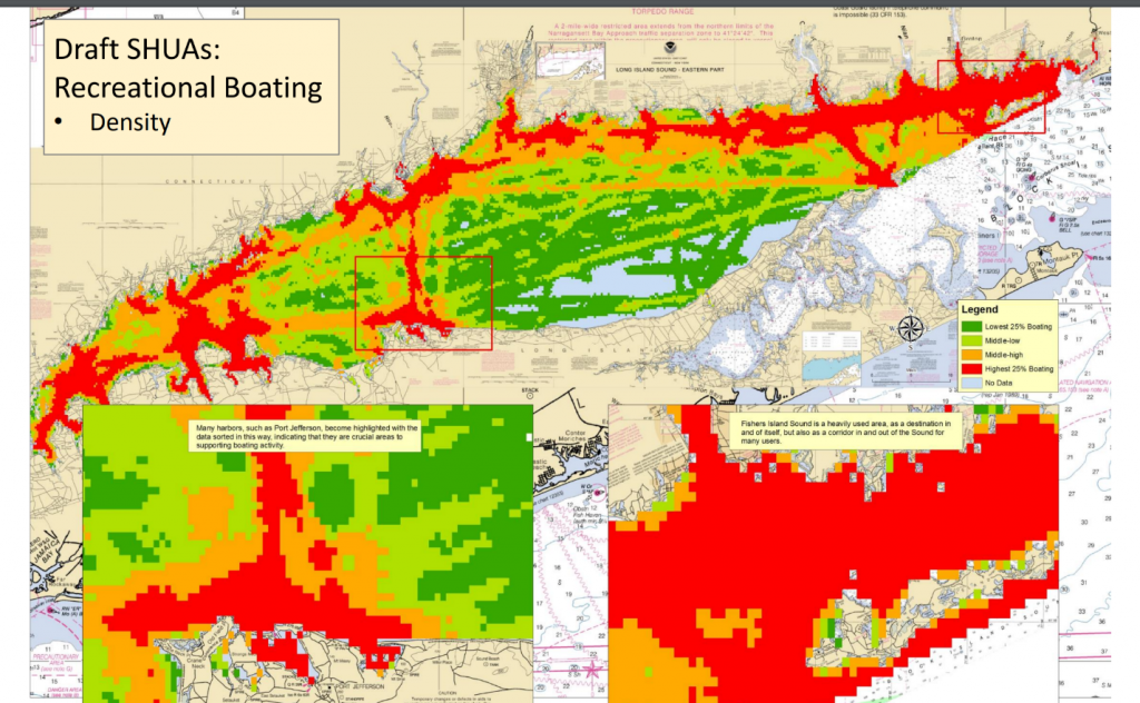
- Mapped out traditional human uses which allows project developers to see how their actions may affect activities such as angling, commercial fishing, sail boat racing, shellfish lease areas, and shipping lanes.
- Collects regularly updated material with the best available science and expertise to ensure regulatory decisions are well-grounded.
- Provides a cooperative tool for citizens, agencies, coastal planners, and industry to use for transparency, early conflict resolution, and streamlining permit discussions for new uses which adds consistency and predictability.
Many mistakes have been made over the years due to poor planning and simple lack of knowledge of potential impacts from well-intentioned development projects (and maybe some not so well-intentioned). With the support of research projects supported through the Long Island Sound Study, coupled with ever evolving satellite mapping and sensor technology, we know a lot more about the Sound than we did even 25 years ago. Putting all this information into one easily accessible data portal on the DEEP website gives every stakeholder a window into the vast information available on the Sound.
Though the program is not regulatory in nature, potential users can use it to identify problems with their proposal ahead of time and maybe gain insight on better areas to locate their particular project. The Blue Plan only considers waters of the Sound deeper than 10 feet given the large number of jurisdictions along the shoreline from municipal zoning and shellfish commissions to marinas and harbors. To avoid all the existing rules and regulations already in place for the shallow shoreline areas the Blue Plan line begins seaward of the 10’ depth contour and, in some cases, avoids deeper waters close to shore and within island groups.

Above all, it is simply a tool for people to use. Anyone can educate themselves both about the wasys other people are using the Sound in their area, as well as the fish, wildlife, and varied habitats that need consideration at all times. This is exactly the process being used as the first offshore wind cable route is under consideration. The project will likely run completely through New York waters and while the developers are not bound by Connecticut statute in New York waters, the Blue Plan maps cover the Sound in its entirety and so the developers are using the Blue Plan along with stakeholder meetings to find the best route to deliver power. The best route means not disturbing unique habitats or getting in the way of commercial fishing practices such as aquaculture or recreational uses such as sailboat racing.
The Blue Plan is a common sense approach to building a better future for the public trust that is Long Island Sound—for ours and future generations. The plan, along with factsheets, resource and use inventory, and all information can be found at the DEEP website.
